Google Maps is one of the easiest and cheapest ways to plan simple delivery routes for small businesses that only intend to deliver to a limited number of stops.
If you are a small business or just starting out, then Google Maps is a viable option to help you plan your delivery and/or collection routes, but it inherently has a number of drawbacks in comparison to a specialist route planning software since it isn’t purpose built for deliveries or collections.
As your logistics operation grows, the task of manually inputting the routes and efficiently navigating between each planned destination in Google Maps becomes increasingly inefficient.
It leaves a lot to be desired when planning complex routes with multiple stops, creating bottlenecks throughout an operation as opposed to solving them.
In this guide, we will outline how to plan delivery or collection routes in Google Maps and the limitations of the software when doing so, while looking at specialised alternatives on the market to help discern which is the better fit for your logistics operation.
How to use the Google Maps Mobile App for planning multi-drop routes for delivery drivers
Getting Started:
- Download the Google Maps App: Begin by downloading the Google Maps app from the App Store (iOS) or Google Play Store (Android).
- Open the App and Select ‘Directions’: Launch the app and select the “Directions” button at the bottom of the screen to begin entering the details of your stand and end point.
Setting Your Delivery or Collection Route:
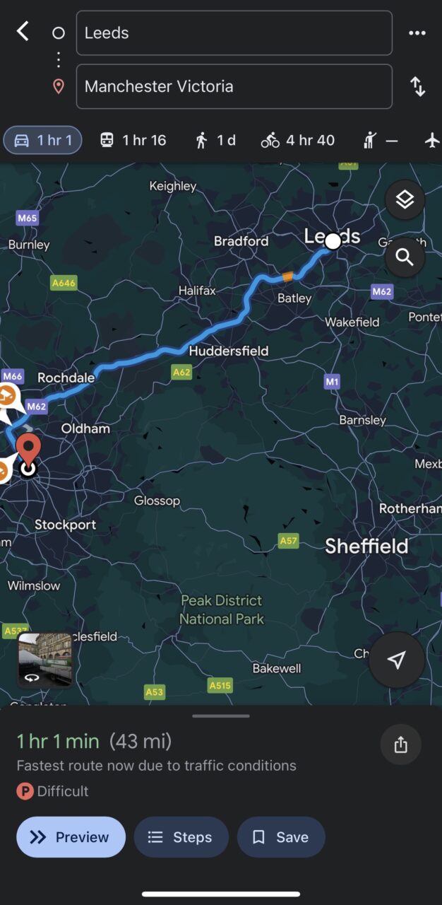
- Enter Start and End Points: In the “Choose starting point” and “Choose destination” fields, input your starting address and final destination.
- Select Mode of Transportation: Choose your preferred mode of transportation (e.g., car, walking, public transit, bike) from the menu above the destination field.
- Add Stops (Optional): If necessary, tap the three-dot menu icon next to the address field and select “Add stop” to include additional touchpoints along your route. You will have to manually order them as desired, and can’t automatically do this by proximity to the next destination.
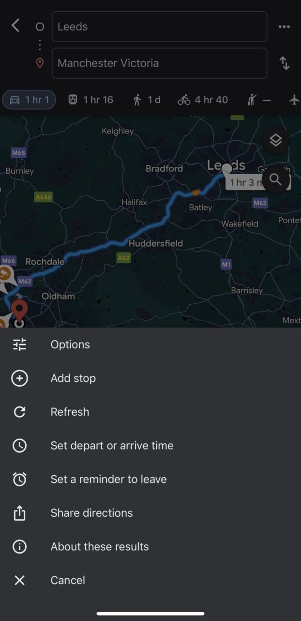
Customising Your Route:
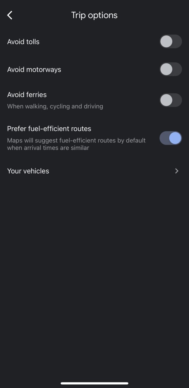
- Adjust Preferences: Use the “Options” menu to customise your route by avoiding tolls, highways, or ferries.
- Review and Optimise: Once you’ve entered your route and preferences, tap “Done” to review the details, including distance, estimated time, and traffic conditions.
Starting Your Journey:
- Begin Navigation: When you’re ready to start, tap “Start” to activate turn-by-turn voice navigation for the route(s) you ordered by location previously.
Additional Tips:
- Double Check: Ensure every address has been entered and ordered correctly.
- Save Routes: For frequently used routes, consider saving them for future reference.
- Check Traffic: Monitor real-time traffic conditions to anticipate potential delays and adjust your route accordingly.
By following these steps, you can use Google Maps as a delivery route planner to plan your journeys and ensure more efficient delivery or collections times, however, it does come with a number of limitations that are worth noting. These limitations are somewhat manageable for a small operation that handles a minimal amount of deliveries and collections per day, particularly at no cost, but they become constraining for businesses that work at scale.
The limitations of planning multi-drop deliveries & collections in Google Maps
- Stop Limit: Google Maps is limited to 10 stops. While there are workarounds, they become cumbersome for larger routes.
- Manual Optimisation: You must manually rearrange stops to find the most efficient route, which can be time-consuming.
- Single Driver: Google Maps only allows planning for one driver at a time.
- Limited Constraints: It doesn’t consider delivery time windows, driver breaks, or offer vehicle-specific navigation, as well as a number of other constraints.
When to consider a dedicated route planning tool
If you frequently deal with more than ten stops per delivery or collection route, and these routes are complex, or if you use and manage multiple drivers per day, a dedicated route optimisation tool can save you a significant amount of time and money. These tools offer features that address the limitations of Google Maps, including:
- Specialised Route Planning: Automatically find the most efficient route order based on delivery or collection addresses at scale in one click.
- Constraint Management: Handling time windows, driver availability, vehicle loads, vehicle fuel capacity and more can be factored into a route.
- Fleet Management: Operations have the ability to turn from a reactive operation to a proactive one by tracking driver locations and communicating accurately any updates with customers.
By understanding the limitations of Google Maps and instead exploring dedicated route planning and route optimisation tools, such as Stream, you can make informed decisions about how to plan your routes most efficiently.
Planning delivery and collection routes through specialist software reduces time and labour costs as the level of manual input is reduced in comparison to Google Maps, particularly when integrated with other software and back office systems where order information is seamlessly imported ready for single-click optimisation.
Using route planning tools
Stream is a popular Transport Management System that provides advanced route planning features, including planning to time windows, single-click optimisation, load balancing, multi-depot routing, creating fixed Milk Runs, and accessing real-time traffic updates for accurate ETAs.
Integrations with a diverse range of ERP, warehouse, accounting, and inventory and order systems helps keep your delivery information in sync across your operation. Google’s alternative solution uses My Maps, and offers the ability to import such information via a spreadsheet, KML file, or GPS file, which is a long-winded, timely process that again comes with limitations.
Once imported into My Maps it isn’t currently possible to navigate the route in Google Maps, it is only possible to visualise the imported data. Again, these addresses would have to be manually inputted into Google Maps and ordered accordingly, whereas Stream’s single-click optimisation finds the most efficient route automatically.
“Given the fact that Relay doesn’t just operate a final mile operation, collecting and delivering from a hyper local point – we thought we needed to look into a solution that would consider all our other touch points in the parcel journey, which are the first mile operation, middle mile operation and last mile operation.” – Relay Technologies
Conclusion
While Google Maps offers a viable route planning solution for free, its use cases are more appropriate for a small operation that delivers or collects a limited amount per day.
Unlike Google Maps’ limit of ten stops, Stream lets you tackle complex routes (even with hundreds of touchpoints) and efficiently manage deliveries and collections at scale, irrespective of the size of the fleet. Stream removes planning roadblocks and logistical bottlenecks by providing additional functionality, such as the ability to plan to specific timeslots and driver availability, create fixed Milk Runs, and much more on a subscription basis.
Book your online demonstration of Stream and find out how you can plan efficient delivery and collection routes in 30 minutes.
